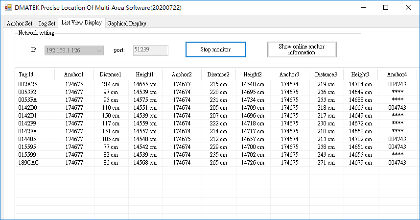
The list display is usually used to quickly test the positioning communication status, because there is no need to create components or parameters. All user need is to make sure the software has the same IP address with the anchor and having a stable power source, by clicking “Start monitor” button, the anchor will start retrieving data coming from the devices
As shown in the figure below, when at least one Anchor is operating normally, the Tag information will appear in the list as long as the Tag is turned on. This list information is displayed in live and refreshes every second, even if the tag is sending at a rate of 0.1 sec per transit. Moreover, there are other details information included in this view mode as well. Including battery level, anchor distances, lost packets, etc. We will have a look at it now.
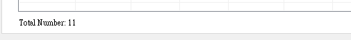
The number of tags will be displayed below the list
Column description
• Tag Id : Tag ID,6 byte
• Anchor1 : ID and name of the anchor 1, 6 byte.
Alias settings will also be displayed at the same time, please refer to the description of Anchor Set for alias settings
• Distance1 : Distance between Anchor 1 and the TAG, unit is cm
• Height1 : The height of Anchor 1 in relation to the sea level, it is the absolute height, unit is in cm.
only applicable for device equipped with height sensor.
• Anchor2 : ID and name of the anchor 2, 6 byte
• Distance2 : Distance between Anchor 2 and the TAG, unit is cm
• Height2 : Absolute height of anchor 2 and the TAG unit is cm
• Anchor3 : ID and name of the anchor 3, 6 bytes
• Distance3: Distance between Anchor 3 and the TAG, unit is cm
• Height3 : Absolute height of anchor 3 and the TAG unit is cm
• Anchor4 : ID and name of the anchor 4, 6 bytes
• Distance4 : Distance between Anchor 4 and the TAG, unit is cm
• Height4 : Absolute height of anchor 4 and the TAG unit is cm
• Anchor5: ID and name of the anchor 5, 6 bytes
• Distance5: Distance between Anchor 5 and the TAG, unit is cm
• Height 5: Absolute height of anchor 5 and the TAG unit is cm
• Tag Height:Absolute height of the TAG in realation to the sea level, unit in cm.
Only applicable for deivces eqippedwith height sensor
• Gsensor : The three-axis gravitational acceleration value of the positioning card Gsensor, in g. e.g. ( X:0.93g Y:-0.01g Z:0.15g )
• Battery : battery penrage of the tag
• Sleep Time : Time to enter Hibernate mode, unit is ms
This parameter is the report time when Tag moves
• No move time : Duration of the TAG being static, unit is second, maximum value is 65534.
Value:65535 indiactes there either no gsensor equipped or faulty sensor
• The last time of receiving data:Latest update of the coordination data.
• The last iterval : Interval between the last update, unit is second
• Packet loss : Statistics of Tag Packet Loss
• Packet received : The total number of received packets of the tag
• Firmware Version: Tag firmware version, 0x20031950 means V5.0 on March 19, 2020
*Sorting of the anchors can be refined from the shortest distance, RSSI and other etc. If area seach is enabled, only the specific anchor and anchor 0’s information will be displayed.
A prompt windown will be displayed after clicking “Show online anchor information” button as shown below. Descriptions of the contnet can be find from the following.
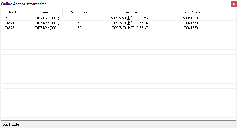
Column description
• Anchor Id : ID of the anchor 1, 6 bytes,
• Group Id : Group name and ID, this will indicate which group does the anchor belongs to
• Report Interval : Interval between each report from the anchor, unit is second
• Report Time : The last report packet received from the anchor
• Firmware Version: Anchor firmware version, 0x20041350 means V5.0 on April 13, 2020
• Total Number : The number of reported anchors